Places a position marker at a location defined by latitude and longitude.
This command is equivalent to the Lat-long option of the GEOMARKPOSTION command.
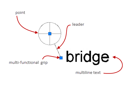
Position markers are annotations that indicate and label locations. A position marker typically consists of a point, a leader line, and multiline text.
This command is available only if the drawing file contains geographic location information.
The following prompts are displayed.
- Latitude
Specifies the latitude of the location. You can specify the latitude in decimal degrees or degrees/minutes/seconds. The command validates the latitude so that it is between +90º and -90º.
- Longitude
Specifies the longitude of the location. You can specify the latitude in decimal degrees or degrees/minutes/seconds. The command validates the longitude so that it is between +180º and -180º .